The first warning arrived in the form of a dead crow nailed to the survey stake.
Nora Quill found it on a Thursday morning in late October, at the eastern edge of a property everybody in Bellwether County called the useless acre.
It was not useless.
That was the first thing she knew.
The second was that whoever had nailed the bird to the stake knew exactly which boundary marker she intended to inspect.
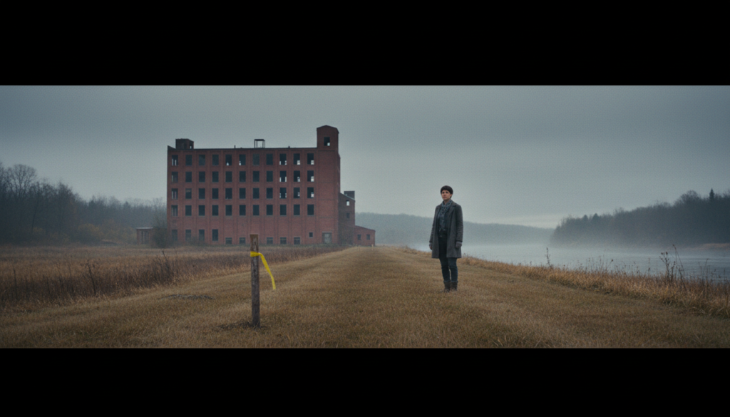
The crow hung upside down, its black feathers moving gently in the wind. Beneath it, someone had wrapped a strip of yellow surveyor’s tape around the wooden post.
On the tape, written in permanent marker, were four words.
YOU MISSED IT BEFORE.
Nora stood with her boots in the wet grass and looked at the message.
She was forty-two, had worked in land surveying for nearly half her life, and possessed a talent for remembering every mistake she’d made, particularly the expensive ones.
She knew what the words referred to.
Seven years earlier, she’d helped prepare a digital boundary map for this same property.
The map had been approved. Filed. Copied into county records. Used in property assessments. Then incorporated into the early planning documents for a proposed industrial development.
There had been an error.
Nora had noticed it before the file was submitted.
And she had kept quiet.
Now somebody had left a dead bird to remind her.
She took photographs without touching the marker, recorded its location, and called the sheriff’s office to report the threat and damage to the stake.
Then she stepped back.
Across the field, the abandoned Bellwether Paper Mill rose behind a line of rusting fences.
Its windows were broken. Its brick walls streaked with rain. Beyond the mill lay a river the color of old iron.
The property had been empty for nineteen years.
Now a development company wanted to turn the site into a distribution and manufacturing campus.
Two hundred jobs, according to its promotional materials.
New roads. Modern buildings. A renewed tax base.
The people of Bellwether had heard versions of that promise before.
Sometimes it came true. Sometimes it didn’t.
The local newspaper had begun calling the project THE SECOND CHANCE.
Nora disliked the phrase.
It assumed the first chance had belonged to everyone equally.
Her telephone rang.
Her younger brother, Cal.
She answered.
“Where are you?”
“At the site.”
“Which site?”
“Don’t.”
A pause.
Then he said, “Did you find the bird?”
Nora went still.
The crow moved in the wind.
“How do you know about the bird?”
Cal exhaled. “Someone sent me a photograph.”
“Who?”
“I don’t know.”
“Cal.”
“Listen, Nora. I need you to leave.”
She looked toward the mill. “Why?”
“Because this is getting out of hand.”
For a moment, neither spoke.
Then Nora said, “What have you done?”
The line went quiet.
Her brother had a particular silence. He used it when deciding whether the truth would cost him more than another lie.
She knew it from childhood. From the stolen money in their mother’s purse. From the car he’d borrowed without permission. From the years after their father’s death, when bills began arriving that nobody understood.
Now she heard it again.
“Cal.”
He whispered, “Please.”
Nora stared toward the mill.
Then said, “I’m not leaving until I know what this acre actually contains.”
Her brother made a small, defeated sound.
“Nora, you don’t understand.”
She looked at the yellow tape.
YOU MISSED IT BEFORE.
“That’s why I’m here.”
Then she ended the call.
The useless acre had been in Nora’s family for ninety-six years.
Not a farm. Not a field anyone could cultivate profitably. Not a pleasant square of land where someone might build a house.
It was a narrow strip running from Old Quarry Road to the river.
Thirty-three feet wide. One thousand three hundred and twenty feet long.
Nora had memorized the dimensions when she was sixteen.
Her father, a surveyor named Edwin Quill, had drawn them on the back of an envelope while waiting for their car to be repaired.
“How many square feet?” he asked.
Nora calculated.
Thirty-three multiplied by thirteen hundred and twenty.
Forty-three thousand five hundred and sixty.
“One acre,” she said.
Edwin smiled. “Exactly.”
She looked at the drawing. It was absurdly long. A thin rectangle.
“That doesn’t look like an acre.”
“What’s an acre supposed to look like?”
“A square.”
Her father shook his head.
“An acre is an area, not a shape.”
She considered.
He continued. “You could have a square about two hundred and nine feet on each side. Or a rectangle sixty-six feet wide and six hundred and sixty feet long. Or this.”
He pointed to the narrow strip.
“Same amount of land.”
Nora frowned. “But they’re completely different.”
“Yes.”
“Then why call them the same thing?”
“Because the number tells you how much land there is, not everything you can do with it.”
He folded the envelope. Handed it to her.
“Remember that.”
Nora did.
She remembered almost everything her father taught her.
What she didn’t remember, until much later, was that a man could know exactly how to measure land and still leave his family with debts they had no idea how to pay.
Edwin died at sixty-one. A sudden illness. A small funeral. A desk full of papers.
The family discovered that he’d borrowed money against several assets to keep his surveying business alive during its final years.
The debts were not all secured against the useless acre, but they consumed much of what Nora and Cal inherited.
Cal was twenty-eight. Nora thirty-five.
Their mother had died years earlier.
They were left with a house, a collection of instruments, old files, and disagreements about what ought to be sold.
Cal wanted to sell everything. Nora wanted to keep the business.
They argued for months.
In the end, the house was sold. The business closed. Most of the equipment went to auction.
The acre remained because nobody offered enough money to make selling it worthwhile.
Then the development plans began.
And suddenly people wanted to know who owned that thin strip.
Nora was working at a surveying consultancy when the early digital mapping contract came through.
The proposed development included the former paper mill and adjoining land.
The old acre formed a narrow connection between the public road and the riverfront edge of the site.
It was not the only theoretical means of reaching the area, but it was the most convenient corridor for the developer’s preferred internal road layout.
The consultancy’s digital parcel map showed the acre as a roughly square polygon near the road.
Its rear boundary stopped far short of the river.
The shape was wrong.
Nora noticed it.
She opened the source records.
The older deed and subdivision plan clearly described a strip thirty-three feet wide by one thousand three hundred and twenty feet long.
She told her supervisor.
He looked at the map. Then at the project’s deadline.
“That boundary doesn’t affect the area calculation, does it?”
“Not the stated acreage.”
“Then we can correct the shape later.”
“The shape determines what the property touches.”
He sighed.
“We’re producing an initial planning base map, not certifying title.”
Nora hesitated.
The distinction mattered.
A digital parcel map was not necessarily a legal boundary survey.
But she knew the incorrect shape could mislead anyone who treated it as authoritative.
She should have documented the discrepancy and insisted that the map carry a clear limitation until it was resolved.
Instead, she left the file as it was.
She was exhausted. Her father had recently died. Her brother was demanding money. The consultancy had threatened redundancies.
She wanted one difficult day to end without another fight.
The map went out.
The mistake traveled.
Seven years later, the development company was still using a version of the wrong geometry.
And Cal, who had inherited the acre jointly with Nora, had apparently been negotiating to sell it.
Without telling her everything.
Nora looked toward the dead crow. Then at the distant mill.
She thought about the difference between an error and a decision.
An error could happen once. A decision could allow it to continue.
She had made both.
The county archive occupied a converted courthouse building that smelled of dust, radiator heat, and paper old enough to resent being touched.
Nora arrived at eleven.
The archivist, Imogen Saye, was seventy, wore a hearing aid, and had the stern face of someone who had spent forty years protecting historical documents from people who considered a stapler an acceptable research tool.
She recognized Nora immediately.
“You’re Edwin’s daughter.”
“Yes.”
“Your father returned books late.”
Nora blinked. “Sorry?”
“Three times.”
She smiled faintly. “Sounds like him.”
Imogen opened a ledger. “What do you need?”
“The original plat for the Quill acre. The 1930 transfer and any later recorded instruments affecting it.”
Imogen looked at her. Then glanced toward the window.
“Another one.”
Nora frowned. “What?”
“Another person asking about that strip.”
“Who else?”
The older woman considered.
“I’m not going to disclose another researcher’s details simply because you ask. But I can show you the records available for public inspection.”
Nora nodded. “Fair.”
Imogen disappeared into the storage room. Returned with a large folder. Placed it on the table.
Then watched as Nora opened it.
The original plat was beautifully drafted. Ink on heavy paper. Careful measurements. Property lines labeled by hand.
The narrow acre extended from Old Quarry Road to the river.
Its two long boundaries ran parallel. Its short ends measured thirty-three feet.
The deed referred to a conveyance completed in 1930, when the mill company transferred the strip to Nora’s grandfather as part of a settlement involving access and drainage works.
Nora studied the record.
Then noticed something written in the margin.
A reference to an additional agreement.
RECORDED ACCESS TERMS — BOOK 48, PAGE 211.
She looked toward Imogen.
“Can I see this?”
The archivist checked the reference.
Then returned with another ledger.
The document was not a deed.
It was an old agreement concerning the use and maintenance of a narrow crossing and a drainage channel serving properties along the river.
The language was complicated.
Some provisions referred to land and industrial facilities that no longer existed.
Others appeared to concern rights that might still affect the present-day parcels.
Nora read carefully.
Then stopped.
The agreement described a crossing near the center of the strip.
A narrow raised section built to allow water to pass beneath it.
She remembered that crossing.
As a child, she’d walked beside her father while he examined the drainage channel after heavy rain.
There had been a small stone culvert. And a path.
Beyond it, several cottages stood near the old mill.
The cottages were still occupied. Seven households.
Nora turned toward Imogen.
“Have these access terms ever been formally released?”
The archivist examined the index.
“I don’t see a recorded release here. That doesn’t establish their present legal effect, of course.”
“I know.”
“Someone will need to review the complete chain of title.”
Nora nodded.
She photographed the relevant references under the archive’s rules and requested certified copies.
Then she asked for the old aerial photographs.
Imogen brought them.
Nora spread the images across the table.
1954. 1968. 1981. 1995.
The acre appeared as a narrow strip leading toward the river.
In the earliest photographs, the crossing was visible.
Later, vegetation obscured parts of it.
A section of the path was gradually covered by industrial debris.
Then the mill closed. The land grew wild.
But the cottages remained.
And the route from the road toward them was visible on the oldest images.
Nora stared.
The wrong digital map made the acre look like a small, isolated parcel beside the highway.
The original documents showed something else.
A continuous corridor.
A piece of land connecting places.
And potentially carrying old access obligations that required careful legal investigation before development could proceed.
She took out her notebook.
Wrote: 33 × 1320 = 43,560.
Then beneath it: THE AREA IS RIGHT. THE GEOMETRY IS WRONG.
She underlined the second sentence.
Imogen watched her.
Then said, “Your father knew about the crossing.”
Nora looked up. “What?”
“He came here years ago to examine the same agreement.”
She stared. “When?”
“Before he died. I can’t tell you why. But he asked for copies.”
Nora felt something cold move through her.
Her father’s files had been sold, stored, or thrown away after the business closed.
She no longer knew what remained.
Imogen continued. “He was very interested in the access language.”
Nora looked toward the old plat. Then toward the photographs.
She had spent seven years believing her father’s acre was an inconvenient remnant of a failed business.
Now she wondered whether he’d been trying to protect something more than land.
She folded the documents carefully.
And went to find her brother.
Cal lived above a tire shop on the south side of town.
His apartment contained a television, two kitchen chairs, a stack of unopened mail, and a photograph of their father standing beside the old paper mill when it was still operating.
Nora noticed the photograph first.
Then the envelope on the table.
NORTHBANK DEVELOPMENT HOLDINGS.
Cal saw her looking. He moved toward it.
Too late.
Nora picked it up.
Inside was an agreement granting the developer an option to purchase the acre.
The proposed price was substantially higher than the amount Cal had mentioned when he first told her someone was interested.
More troubling was the signature page.
Cal Quill.
Nora Quill.
She stared at her own name.
It was written in a handwriting almost, but not quite, like hers.
She looked up.
“Did you sign this?”
Cal went pale.
“Nora—”
“Did you?”
He sat down. “Yes.”
She looked at the page again.
There were mistakes. The tail of the Q was wrong. The letters leaned too far forward.
Their father had taught both children to forge his signature when they were young, not for dishonest purposes but as a lesson in how easily a convincing-looking mark could be imitated.
Cal had always been better at it.
Nora placed the agreement on the table.
“You forged my name.”
He stared at his hands.
“I was going to tell you.”
“When?”
“Before closing.”
“You granted an option over jointly owned land using my signature.”
He said nothing.
She felt sick.
“How much have they paid you?”
Cal looked away.
“Nora.”
“How much?”
“Twenty-four thousand.”
“Where is it?”
He gave a small laugh. A hopeless sound.
“Mostly gone.”
Nora stared.
Cal explained.
He had lost a major contract. Borrowed money to cover the shop he once owned. Sold tools. Borrowed more.
Then used the option payment to settle some of the debts that were putting him under pressure.
He had not told Nora because he was ashamed.
He had also been angry.
Angry that she had left Bellwether to find work.
Angry that he remained there managing their father’s affairs.
Angry that she seemed able to speak about the acre as though it were a matter of geometry rather than rent, debt, and the fear of losing everything.
Nora listened.
She did not interrupt.
Then she asked, “Did you put the crow on my survey stake?”
Cal looked up sharply. “No.”
“Someone knew I’d be there.”
“The developer’s site people knew. I told them you were inspecting the boundary.”
“Why?”
“Because I hoped they’d explain how little difference the old records made.”
Nora looked at him.
“Little difference?”
He rubbed his eyes.
“They’re building a factory campus. People need work.”
“The acreage reaches the river. Their map stops near the road.”
“They know.”
The words struck.
Nora went still. “What?”
Cal stared. Then looked away.
She took a step closer.
“Cal. What do they know?”
He swallowed.
“The project manager said the correct boundary was a complication they hoped to resolve during the purchase.”
Nora felt cold.
“So they know the geometry is wrong.”
“Yes.”
“And they’re still circulating the old map.”
“I don’t know which documents they’re using now.”
Nora looked toward the envelope.
The company had told potential investors and county officials that its preferred layout required acquiring several adjacent parcels.
The acre was listed as a minor frontage purchase.
A small addition beside the public road.
Not a continuous strip reaching the river.
Not a corridor crossing old drainage works.
Not land potentially affected by recorded access arrangements serving nearby households.
She looked at her brother.
“Did they tell you about the cottages?”
Cal frowned. “What cottages?”
“The seven homes near the river. The old crossing.”
He stared.
Nora understood then that he hadn’t known.
He had sold something he didn’t understand, using a signature that wasn’t his, to people who had reason to understand it better.
She felt the familiar temptation to take charge.
To tell him what to say. How to confess. How to repair the damage.
She’d spent their childhood doing that. Spent her twenties doing it. Spent the years after their father’s death doing it.
Now she looked at the forged agreement. And stopped.
“You need a lawyer.”
Cal closed his eyes.
“Are you going to report me?”
“I’m not going to pretend that signature is mine.”
He looked at her.
“Nora, please.”
She felt her throat tighten.
“I’ll tell the truth about what happened. I won’t decide the legal consequences for you.”
He stared. Then nodded.
She picked up the old photograph of their father.
Edwin stood beside the mill gate, holding a tripod. His shirt was dirty. His face tired. He was smiling.
Nora looked at him for a long time.
Then set the photograph down.
“I found the access agreement,” she said.
Cal frowned. “What agreement?”
“The one Dad was studying before he died.”
Her brother looked confused.
She continued.
“The acre isn’t just frontage. It’s a long corridor. We need to know what rights affect it before anybody sells or builds over it.”
Cal rubbed his face.
“Then what do we do?”
Nora considered.
For once, she refused to answer as though she were the only person qualified to make the decision.
“We get proper title advice. I correct the survey record I helped make wrong. And the people living beside that land need to know the development may affect them.”
Cal looked toward the window.
Then whispered, “They’re going to hate us.”
Nora looked at him.
“Some of them may have good reasons.”
The public meeting took place eleven days later.
The hall was full.
Mill workers who hoped the project would bring employment. Shop owners who wanted more customers. Residents who worried about traffic and noise.
People who simply wanted the abandoned factory removed. Others who feared the promised jobs would arrive without the promised wages.
Nora stood near the back with a folder beneath her arm.
Cal sat in the second row beside the lawyer he’d retained.
He had given a statement concerning the unauthorized signature and the money he’d received.
The matter was now being handled through appropriate legal channels.
There was no quick forgiveness.
No promise that the consequences would be minor.
Nora hadn’t spoken to him for three days.
She didn’t know when she would.
On the stage, the developer’s representative presented the site plan.
Modern buildings. New loading roads. Landscaping. A riverfront area that would supposedly become more accessible to employees.
The projected jobs appeared on the screen in large numbers.
People murmured approvingly.
Nora understood why.
Bellwether had lost too many employers.
A working factory meant paychecks, apprenticeships, and families able to remain in town.
Those hopes were real.
The problems with the map were real too.
When the chair invited questions, Nora raised her hand.
She introduced herself.
Declared her previous role in preparing the erroneous digital map.
Then presented the supporting records.
The old deed. The plat. The area calculation. The boundary dimensions. The access agreement. The aerial photographs.
She did not announce that the developer had committed a crime. She could not prove that.
She did not say the proposed works were necessarily unlawful.
That required legal and planning review.
She explained what she could establish.
The parcel had been depicted incorrectly.
The old documents described a strip thirty-three feet wide and a quarter-mile long.
The proposed road layout relied on treating that strip as though its geometry and associated interests were already resolved.
They were not.
A man in the front row called out.
“How big is the thing, then?”
Nora looked toward the screen.
“One acre.”
He laughed.
“That’s what everybody keeps saying.”
She nodded.
“An acre is forty-three thousand five hundred and sixty square feet.”
She pointed toward the first diagram.
“A square acre would be roughly two hundred and nine feet along each side.”
Then the second.
“But a parcel thirty-three feet wide and thirteen hundred and twenty feet long contains exactly the same area.”
The room grew quieter.
She showed the two shapes at the same scale.
One compact.
One narrow and astonishingly long.
“They’re both one acre,” she said. “But they connect to very different things.”
A woman near the aisle raised her hand.
She lived in one of the river cottages.
“Does that mean they can close our crossing?”
Nora looked toward her.
“I can’t determine that from the survey alone. The recorded agreement needs legal interpretation, and the current access arrangements need to be established before the proposed design is approved.”
The woman nodded.
“Will somebody actually look at it?”
Nora turned toward the planning chair.
“That’s what I’m asking.”
The meeting lasted another two hours.
There were angry questions.
The developer agreed to provide corrected plans and cooperate with review of the boundary and recorded interests.
The planning body deferred its decision pending additional information.
The seven households would be included in the consultation process concerning access.
Environmental questions about the former industrial site were referred for appropriate investigation rather than answered by speculation.
Nothing was settled that night.
The jobs were not guaranteed.
The project was not canceled.
The disputed acre was not suddenly worth millions.
Cal still faced consequences for what he’d done.
And Nora’s own professional conduct would be reviewed because of her role in the original map.
The outcome was untidy.
She found it difficult to call that a victory.
After the meeting, a man approached.
He wore a work jacket with the name of the old paper mill stitched above the pocket.
He was perhaps sixty.
“You the surveyor?”
“Yes.”
“My father worked at the mill.”
Nora nodded. “So did mine, for a time.”
The man looked toward the folded map.
“Your father used to come down by the cottages. He said the old crossing mattered.”
Nora felt something tighten.
“Did he say why?”
“Because the families had been using it for generations. He didn’t want somebody building over it without finding out what they’d be taking away.”
She looked down.
The man continued.
“I want that factory site working again.”
“So do a lot of people.”
He nodded.
“But if they can’t get a road drawn right, I’d like them to check the rest before they start pouring concrete.”
Nora smiled faintly.
“So would I.”
He offered his hand.
She shook it.
Then he went home.
In December, Nora returned to the acre.
The dead crow was gone.
The damaged survey stake had been replaced through the proper process.
The grass had turned brown. Frost clung to the edges of the drainage channel.
She walked along the narrow strip with a licensed colleague who was conducting the formal boundary work.
The old culvert was still there.
Partly concealed by weeds.
The stonework had deteriorated.
Water moved beneath it in a dark, narrow stream.
Nearby, the remains of the old path continued toward the cottages.
Nora stood beside the crossing.
She remembered walking here with her father.
He had pointed toward the river.
Told her to measure twice.
Then asked whether she understood why a line on a map could matter.
She’d thought he meant money.
Ownership.
The difference between two people arguing over a fence.
Now she understood something else.
A boundary could determine whether a person had access to a road.
Whether a home remained connected to a town.
Whether a plan showed the real dimensions of the land it intended to use.
Whether people were consulted before decisions were made about places where they lived.
An acre was an area.
But an acre was also somewhere.
It had neighbors.
A history.
Edges that touched other things.
And people who had reason to care what happened there.
Her colleague examined the field notes.
“Ready to continue?”
Nora nodded.
They walked north.
Thirty-three feet across.
A quarter-mile long.
One acre.
The same number she’d calculated as a child.
The same parcel she’d failed to represent correctly seven years earlier.
She could not undo that decision.
She could correct the record.
Tell the truth.
Accept the consequences.
Then do better work.
Near the road, she stopped and looked back.
The acre stretched behind her, almost invisible beneath the winter grass.
From this angle, it seemed too narrow to matter.
But the river lay at the far end.
The cottages beyond the crossing.
The old mill.
The future development.
All connected by that thin, difficult piece of land.
Nora took out her notebook.
Wrote the verified measurements.
Then, beneath them, added a sentence that wasn’t part of the survey.
WHAT A THING MEASURES IS NOT ALL THAT IT MEANS.
She closed the notebook.
And went back to work.
The End.
Editorial Land Measurement Note
How big is an acre? One acre equals exactly 43,560 square feet, or 4,046.8564224 square meters (approximately 0.405 hectares). An acre measures area, not shape. A 33-by-1,320-foot rectangle contains exactly one acre; so does a 66-by-660-foot rectangle. A square acre measures approximately 208.71 feet on each side. An acre is 1/640 of a square mile. Land area alone cannot establish legal ownership, access rights, or building permission; authoritative surveys and title records matter. Bellwether County, the Quill family, the paper mill, and the property dispute are fictional.